US $1 - 10 / Set

Product Name: Windows Mobile 6.5 SBAS 1-3m Outdoor Usage GIS Best Handheld GPS |
| Port: | Shenzhen |
|---|---|
| Supply Ability: | 100 Pack/Packs per Month Strong ability for buyer |
| Payment Terms: | L/C,T/T,Western Union |
| Packaging Details: | Standard export package with carton case |
|---|---|
| Delivery Details: | Within 10 working days |
Windows Mobile 6.5 SBAS 1-3m Outdoor Usage Best Handheld GPS
With Windows Mobile 6.5 you may upload necessary utilities or software on your Qmini M ,to suit your next job .
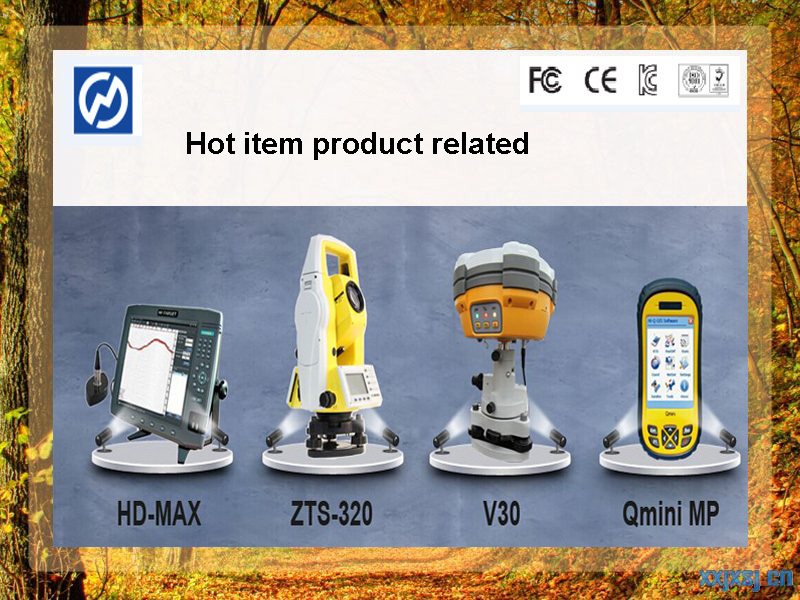
You can collect GIS/GPS points and maps via the GIS application of your choice , either a third-party software such as ESRI ,ARCPAD or the proprietary Hi-Target application.


* Real time co-ordinates on site.
* Accuracy to 15mm in level over 10Km.
* No need for intervisibility between survey stations.
* Fast collection of survey data.
* 24hr a day availability and operation.
* Availability and operations in all weather conditions.
* Quick and reliable fixing Ordinance Survey Datum.

| Model | Qmini |
| SYSTEM CONFIGURATION | |
| Operating system | Windows Mobile 6.5 |
| Processor | 806 MHz |
| RAM | 256 MB RAM |
| Flash memory | 8 GB |
| Display | 3.7 inch LED, 640×480 resolution |
| GPS FEATURES | |
| GPS L1 & BDS B1 | |
| Built-in high sensitivity anti-interference GPS antenna | |
| Update rate | 1 fix/s (user configurable) |
| Update rate | 1 Hz (configurable w/ future FW 2 Hz Max) |
| Time to first fix (TTFF) | 35 seconds (typical) |
| POSITION ACCURACY | |
| Single Point Positioning | 5 m |
| APPLICATION FUNCTIONS | |
| 5 million pixel camera with LED | |
| Built-in speaker | |
| COMMUNICATION INTERFACE | |
| Bluetooth Mini USB ;MicroSD card slot, support up to 32 GB Built-in 3G module | |
| WIFI | 802.11b/g |
| POWER SUPPLY | |
| 3.7V, 3100 mAh lithium battery, up to 8 hours continuous work, online charging | |
| PHYSICAL PROPERTIES | |
| Size | 152 mm x 82 mm x 32 mm |
| Weight | 315 g (with battery) |
| Operating temperature | below 20℃to above 70℃ |
| Storage temperature | below 30℃ to above 80℃ |
| Dustproof / waterproof | IP65 |
| Anti-shock | 1.5 m free fall |
| 10 keys, with the four arrow keys | |
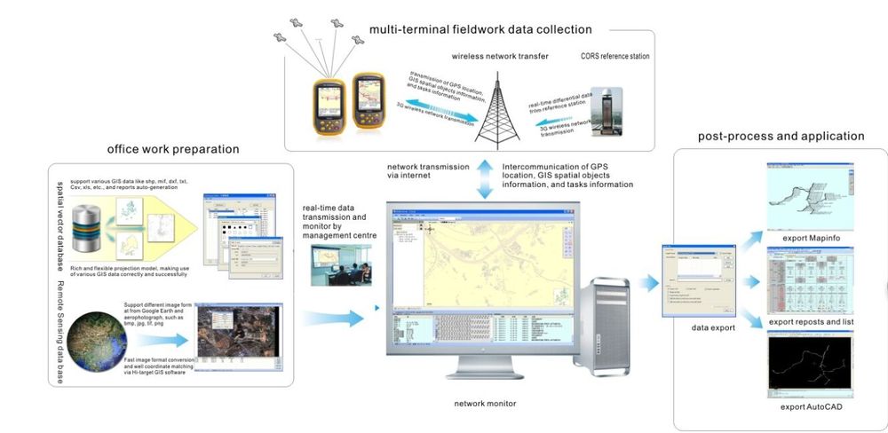
How does the GIS information management system run through our product?

1.We have more than 6 years of developed sales chanels in many countries.
2.Our company are highly acclaimed and favorably accepted by numerous customers and possessed of the right to import and export.
3.We prominent emphasize the human concern,respect,rust in company management,as we as stimulate staff's sense of responsibility and the sense of mission.
4.Inspected by the Inspection Institution of Bureau Veritas Certification.
5.100% QC inspection Before Shippment.
6.CE/FC listed,competitve price.effective delivery.
![]() Trade Terms
Trade Terms
1. Payment: T/T,Western Union,L/C
2.Delivery Time: within 10 working days
3. Warranty: 1 year
4. Packing information: carton cases with standard exporting package
Our packing option